


OVERview
Overview
This section maps the traditional cannabis-growing regions of the world, organized by continent, country, and (where possible) locality. It’s a navigational hub for understanding where landrace cannabis has historically been cultivated, how these areas differ, and what kinds of plants and practices define them.
Unlike modern hybrid cultivation, which is often delinked from place, landrace cannabis is deeply rooted in specific ecologies and cultures. A growing region here isn’t just a point on a map, it’s an agro-cultural system shaped by climate, altitude, soil, trade, migration, language, law enforcement and taboo among other factors. These regions aren’t static either: borders shift, traditions change and plants move with people. But patterns emerge. Cannabis grown in the Indo-Gangetic plain differs profoundly from that of the Ethiopian highlands or the Hindu Kush valleys and those differences matter.
Our goal is to document and preserve this diversity with as much precision as possible. Each entry links to field notes, seed accessions and glossaries where relevant. Navigation moves from broad to granular: Asia → India → Bengal → Kalimpong → Todey-Tangta. Not all areas go that deep yet, but that’s the direction we’re heading.
Use this page to explore. Click through by continent, or follow direct links to specific valleys, districts and enclaves. As always, what you see here reflects what we’ve found so far, our research is ongoing and much of what matters remains unwritten.

ASia
Asia is the heartland of traditional cannabis cultivation. It holds the greatest known diversity of landrace domesticate populations, as well as large feral zones and culturally distinct cannabis use traditions that go back millennia.
From the forested foothills of the Eastern Himalaya to the high deserts of Central Asia and the tropical monsoon zones of mainland Southeast Asia, the region’s growing areas reflect radically different agroecological conditions, cultural histories, and plant types.
Most of the world’s hashish-making traditions originate here: Afghanistan, Nepal, India, Pakistan, Kashmir as do some of the earliest records of cannabis use in medicine and ritual. But Asia also includes lesser-known regions where traditional cultivation continues: upland Northeast India, the mountain margins of Laos and Thailand, the Chin and Naga hills of Myanmar and the drylands of Iran, Uzbekistan and Xinjiang.
Landrace Growing Countries of Asia
Organized by country, then region, province, district, area and/or village.
This section is under active expansion based on our fieldwork.
Countries covered (click to navigate):
-
India
-
Nepal
-
Pakistan
-
Afghanistan
-
Tajikistan
-
Uzbekistan
-
China (Xinjiang, Yunnan)
-
Laos
-
Thailand
-
Myanmar
-
Cambodia
-
Vietnam
-
Iran
-
Turkey (border case, included here)
Each country page includes traditional growing zones, relevant seed accessions, and links to glossary terms and field reports where available.

India
Introduction
India is one of the world’s primary centers of cannabis domestication. Across its vast ecological and cultural range, traditional cultivation persists in highland valleys, lowland floodplains, dry interior plateaus, and shifting hill-farming systems. Landrace populations are deeply embedded in local farming rhythms, seasonal festivals, seed-saving practices and forms of use that include charas, ganja, bhang, seeds as food and more.
This page introduces the major growing regions of India, structured by ecological zone and grounded in ongoing fieldwork. Each region includes nested entries by province, district, and village where applicable.
Geography and Ecology
India’s cannabis diversity is inseparable from its environmental diversity. The country spans multiple biogeographic zones: from the subtropical Himalaya to the Indo-Gangetic floodplains to the dry interiors of the eastern Deccan. Regional cultivars are adapted to specific altitudes, photoperiods, rainfall patterns, and soils.
Understanding local environmental pressures helps explain why a late-flowering resin cultivar thrives in Parvati, while drought-tolerant seed types persist in Koraput.
→ Learn more about the geography and ecology of cannabis in India by clicking here
History
Cannabis use in India dates back thousands of years. It appears in early medical texts like the Atharva Veda and Sushruta Samhita and later in Islamic pharmacopoeia, Tantric ritual practice and folk traditions. The colonial period introduced state-managed ganja production, particularly in Bengal, Bihar, and Orissa. After independence, cannabis became criminalized but traditional use continues in many regions, often in defiance of legal frameworks.
→ Learn more about the history of Cannabis in India by clicking here
Culture and Religion
Cannabis is woven into multiple strands of Indian religious and social life. Among Shaivite ascetics, charas and bhang are used in devotional ritual. In rural contexts, bhang is consumed during festivals like Holi, and cannabis plants are sometimes cultivated as household or boundary plants. The meanings of use vary: sacred, recreational, medicinal, social, or agricultural—depending on region, caste, and circumstance.
→ Glossary entries: [Bhang], [Charas], [Sadhu], [Shaivism]
Law and Politics
While cannabis was traditionally tolerated or state-managed in many parts of India, prohibition policies introduced in the 20th century criminalized its cultivation and sale. Enforcement varies widely by region, and in many zones, small-scale cultivation continues under tacit community protection or state neglect. Efforts to revive or formalize cannabis agriculture (particularly for industrial hemp) are growing, but often ignore or overwrite traditional drug-use cultivars and landraces.
→ See Cannabis and the Law in India

Growing Regions of India
Below is a structured index of India’s known landrace cannabis growing regions: places we’ve documented through fieldwork, collected seeds from or received reliable reports about. Regions are organized hierarchically by ecological zone, then by area, province, district, village, and in some cases, down to specific named fields.
The list includes:
-
Actively cultivated landrace populations
-
Feral populations with ethnobotanical relevance
-
Historical, undocumented, or legendary sites preserved in oral histories or local memory
Where applicable, entries are marked with tags indicating their status:
[Legendary] – Known from oral tradition but not directly verified
[Extinct] – No longer cultivated or accessible in situ
[Speculative] – Suspected to exist but currently unconfirmed
[Status Unknown] – Previously documented but current status unclear
[Undocumented] – Reported but not yet directly observed by us
[Eradicated] – Confirmed destroyed by enforcement
[Eradications Ongoing] – Active eradication observed or reported
Absence of a tag indicates that the area has been directly documented, accessed, or both.
This section is a living archive, actively updated based on ongoing fieldwork. It’s designed to serve as a shared reference point for researchers, growers, and conservationists working to understand and preserve India’s landrace cannabis diversity.
Click any of the names below to jump to the full-length entry - even if they’re not underlined.
Himachal Pradesh
Kullu District
Kullu Valley
- Kullu Valley (Proper)
- Manali
- Old Manali
- Vashisht
- Vashisht Village
- Bashisht Fields [Status Unknown]
- Chanderkhani Valley
- Naggar
- Rumsu
- Rumsu Village [Eradications Ongoing]
- Upper Fields
- Pulag
- Pulag Village [Eradications Ongoing]
- Upper Fields
- Hallan
- Hallan Village [Eradications Ongoing]
- Upper Fields [Status Unknown]
- Pichhli Valley [Undocumented]
Parvati Valley
-
Pini [Eradications Ongoing]
-
Rasol
- Rasol Village [Eradications Ongoing]
- Rasol 'Parla Thatch' Field
- Rasol 'Vairam' Fields [Eradications Ongoing]
- Rasol 'Vairam Top' Fields
- Rasol 'Jah' Fields
- Rasol 'Oridhar' Fields
- Gargi
- Gargi Village
- Gohar
- Gohar Village
- Grahan
- Grahan Village [Eradications Ongoing]
- Grahan 'Kutla' Fields
- Grahan 'Upper' & 'Lower' 'Terraces' Fields [Eradications Ongoing]
- Grahan 'Riverside' Fields [Eradicated in 2024]
- Pulgi Village [Eradications Ongoing]
- Thunja Fields [Eradications Ongoing]
- Thunja-Kutla Fields
- Lapas
- Lapas Village
- Lapas 'Upper' Fields
- Lapas 'Sargi Top' Fields
- Lapas 'Bareonah' Fields
- Barshaini
- Barshaini Bazaar
- Tosh
- Tosh Village [Eradications Ongoing]
- Tosh 'Upper' Fields
- Tosh Lower 'Kutla' Fields [Eradicated in 2005]
- Tosh Upper 'Kutla' Fields [Eradications Ongoing]
- Tosh 'Goi' Fields
- Tosh 'Chorang' Fields
- Tosh 'Sharam Thatch'
- Malana Valley
- Nirang
- Nirang Bazaar
- Nirang Village [Eradications Ongoing]
- Nirang 'Upper' Fields
- Nirang 'Top' Fields
- Galeno's Valley Fields
- Malana
- Malana Village
- Malana 'Terraces' Fields [Eradications Ongoing]
- Malana 'Tosco' Fields
- Weling (Wailing) Valley
- Weling Village
- Weling 'Upper' Fields
- Mejigh (Magic) Valley
- Mejigh Village
- Mejigh 'Upper' Fields
- Atolang (Atuding)
- Atolang Village
- Atolang 'Upper' Fields
- Waichin (Wechin) Valley
- Waichin Village [Eradications Ongoing]
- Waichin 'Upper' Fields [Eradications Ongoing]
- Nirang
Sainj Valley [Status Unknown] [Undocumented]
Kinnaur
Rampur
Saharanpur
Kangra
Chamba
Lahaul
Spiti
Jammu & Kashmir
Kashmir
Jammu
Ladakh
Eastern Himalayas
West Bengal
Darjeeling District
Kalimpong District
-
Upper Jhaldaka Valley
-
Paren Village
-
Upper Paren
-
Suruk Village
-
-
Today-Tangta Valley
-
Todey Bazaar
-
Chisang
-
Tangta Village
-
Sikkim
Arunachal Pradesh
West Kameng District
Dooars-Terai
Terai
Uttar Pradesh
Western Dooars
West Bengal
Jalpaiguri District
Mal Bazar
-
Mal Bazaar (Proper)
-
Washabari
-
Bagrakote
Matiali
-
Chapramari Wildlife Sanctuary
-
Sipchu Village
Nagrakata
-
Nagrakata (Proper)
-
Sukhanibasti
-
Grassmore
-
Looksan
-
Deana Tea Gardens
Banarhat
-
Banarhat (Proper)
-
Lakhipara
Alipurduar District
Alipurduar
-
Salkumar
-
Salkumarhat (Bazaar)
-
(Forgot)
-
-
Mondolpara
-
Bandhani
-
Bandhanihat (Bazaar)
-
Sidhabari
-
Suripara
Madarihat-Birpara
-
Madarihat (Proper)
-
Purba (East) Madarihat
-
-
Khairbari
-
Uttar (North) Khairbari
-
Dakshin (South) Khairbari
-
Khairbari Forest
-
-
Deogaon
-
Paschim (West) Deogaon
-
Dakshin (South) Deogaon
-
-
Hollong
-
Khauchandpara
-
Jamtola
-
Totopara Forest
-
Ballaguri
Kalchini
-
Kalchini (Proper)
-
Hasimara
-
Latabari
-
Dakshin (South) Latabari
-
-
Hamiltonganj
Central Dooars
Assam
Eastern Dooars
Assam
Northern Plains
Punjabi Plains
Punjab Province
Chandigarh District
Ganga-Yamuna Doab
Uttar Pradesh
Rohilkand Plains
Uttar Pradesh
Avadh Plains
Uttar Pradesh
Eastern Plains
- Bihar
- North Bihar Plains
- South Bihar Plains
- West Bengal
- North Bengal Plains
- Jalpaiguri District
- Jalpaiguri
- Haldibari
- Cooch Bihar District
- Mekliganj
- Fulkardabri
- Fulkardabri Kasiabari
-
- Jalpaiguri District
- Bengal Basin
- Rajshahi
- North Bengal Plains
Brahmaputra Valley
Assam
Indo-Burman Range
-
Assam
-
Patkai Bum
-
Mikir Hills
-
-
Nagaland
-
Naga Hills
-
-
Meghalaya
-
Garo Hills
-
Khasi Hills
-
Jaintia Hills
-
-
Manipur
-
Manipur Hills
-
-
Mizoram
-
Mizo Hills
-
-
Tripura
-
Tripura Hills
-
North Central Highlands
Madhya Pradesh
South Central Highlands
Madhya Pradesh
Eastern Plateau
Jharkhand
-
Chota Nagpur Plateau
-
Garjat Hills
-
Bagelkhand Plateu
-
Mahanadi Basin
Chattisgarh
Orissa
North Deccan
-
Madhya Pradesh
-
Maharashtra
South Deccan
-
Karnataka
-
Telangana
-
Western Ghats
Eastern Ghats

Western Himalayas
The Western Himalayas are among the most well-known cannabis-growing regions in India. Stretching across Himachal Pradesh, Jammu & Kashmir, and parts of northern Uttarakhand, this zone supports high-altitude cultivation systems centered on resin production, particularly hand-rubbed charas. Plants here are typically late-flowering, large-framed, selected for trichome coverage, resin consistency and structural resilience in steep terrain.
Cultivation is concentrated in valleys between 1,500 and 3,000 meters, where cannabis is integrated into local subsistence economies, seasonal labor cycles and informal land-use agreements. Many growers maintain long-standing seedlines adapted to local conditions. Despite legal pressure and ongoing eradication campaigns, cultivation continues in hundreds of villages and highland fields, often in partial view of state authorities.
This section includes both active cultivation zones and surrounding areas of genetic and cultural significance. It reflects on-the-ground documentation, seed collection, and interviews with cultivators across multiple districts. Subsections are organized by valley and district, with further breakdowns to village and named field level where applicable.
Map of Western Himalayan landrace cannabis growing regions:

Areas covered:
Himachal Pradesh
Kullu District
Kullu Valley
- Kullu Valley (Proper)
- Manali
- Old Manali
- Vashisht
- Vashisht Village
- Bashisht Fields [Status Unknown]
- Chanderkhani Valley
- Naggar
- Rumsu
- Rumsu Village [Eradications Ongoing]
- Upper Fields
- Pulag
- Pulag Village [Eradications Ongoing]
- Upper Fields
- Hallan
- Hallan Village [Eradications Ongoing]
- Upper Fields [Status Unknown]
- Pichhli Valley [Undocumented]
Parvati Valley
-
Pini [Eradications Ongoing]
-
Rasol
- Rasol Village [Eradications Ongoing]
- Rasol 'Parla Thatch' Field
- Rasol 'Vairam' Fields [Eradications Ongoing]
- Rasol 'Vairam Top' Fields
- Rasol 'Jah' Fields
- Rasol 'Oridhar' Fields
- Gargi
- Gargi Village
- Gohar
- Gohar Village
- Grahan
- Grahan Village [Eradications Ongoing]
- Grahan 'Kutla' Fields
- Grahan 'Upper' & 'Lower' 'Terraces' Fields [Eradications Ongoing]
- Grahan 'Riverside' Fields [Eradicated in 2024]
- Pulgi Village [Eradications Ongoing]
- Thunja Fields [Eradications Ongoing]
- Thunja-Kutla Fields
- Lapas
- Lapas Village
- Lapas 'Upper' Fields
- Lapas 'Sargi Top' Fields
- Lapas 'Bareonah' Fields
- Barshaini
- Barshaini Bazaar
- Tosh
- Tosh Village [Eradications Ongoing]
- Tosh 'Upper' Fields
- Tosh Lower 'Kutla' Fields [Eradicated in 2005]
- Tosh Upper 'Kutla' Fields [Eradications Ongoing]
- Tosh 'Goi' Fields
- Tosh 'Chorang' Fields
- Tosh 'Sharam Thatch'
- Malana Valley
- Nirang
- Nirang Bazaar
- Nirang Village [Eradications Ongoing]
- Nirang 'Upper' Fields
- Nirang 'Top' Fields
- Galeno's Valley Fields
- Malana
- Malana Village
- Malana 'Terraces' Fields [Eradications Ongoing]
- Malana 'Tosco' Fields
- Weling (Wailing) Valley
- Weling Village
- Weling 'Upper' Fields
- Mejigh (Magic) Valley
- Mejigh Village
- Mejigh 'Upper' Fields
- Atolang (Atuding)
- Atolang Village
- Atolang 'Upper' Fields
- Waichin (Wechin) Valley
- Waichin Village [Eradications Ongoing]
- Waichin 'Upper' Fields [Eradications Ongoing]
- Nirang
Sainj Valley [Status Unknown] [Undocumented]
Gushaini Valley [Status Unknown] [Undocumented]
Jibhi Pass [Status Unknown] [Undocumented]
Kinnaur
Rampur
Saharanpur
Kangra
Chamba
Lahaul
Spiti
Jammu & Kashmir
Kashmir
Jammu
Ladakh
Himachal Pradesh

Overview
Himachal Pradesh is a mountainous state in northern India, situated along the southern face of the western Himalayas. It extends from the Siwalik foothills near the Punjab border to the high ranges along the Tibetan frontier. Elevation across the state ranges from under 500 meters to over 6,000 and Cannabis is found growing all throughout, however, large scale cannabis cultivation is concentrated between 1,300 and 3,500 meters, where the climate supports full-season growth and resin maturation.
The landscape is defined by steep valleys carved by glacial rivers, chief among them the Beas, Ravi, Sutlej and their tributaries. Most cannabis is grown on terraced slopes above these rivers, where land is either privately held, communally managed, or informally claimed. Fields are often cut into ridgelines or perched at the margins of forest zones, sometimes hours from the nearest road.
Kullu District forms the core of Himachal’s cannabis belt, with cultivation centered in the Beas watershed and its side valleys—Parvati, Malana, Chanderkhani, and Sainj. These areas are densely settled and agriculturally active, with many villages situated between 1,800 and 2,500 meters. Further east, Kinnaur District rises toward the Tibetan Plateau and supports more fragmented cultivation in isolated hamlets. To the north, Lahaul and Spiti contain high-altitude basins with a very short growing window; cannabis is rare here and often reported but not widely visible. In the west, Chamba and Kangra districts contain colder, more temperate valleys where scattered cultivation occurs on south-facing slopes and streamside terraces.
The region is seismically active, geologically young, and highly erosional. Soils range from sandy glacial outwash to thin brown hill soils over shale and granite. Access varies by valley—some are connected by all-weather roads, while others remain cut off for part of the year. Orientation within Himachal means understanding watersheds, slope direction, and altitude more than any administrative border.

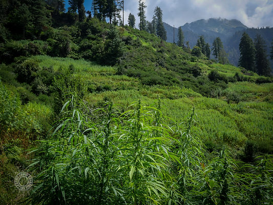
atolang village - malana valley (3000m A.S.L.)
Cannabis cultivation in Himachal is not uniform. It spans countless valleys and microclimates, with variation in field layouts, plant structure, flowering time, resin content, seed selection and social meaning. While international attention has focused on places like Malana and Parvati, large parts of the state (including Chamba, Kangra, Kinnaur, and Lahaul–Spiti) remain underdocumented but active. In many areas, cannabis is cultivated alongside maize, rajma (kidney beans) or fodder crops and is interwoven with customary land use, informal tenure systems and household-level seed saving.
This section provides a full reference to cannabis-growing regions in Himachal Pradesh, organized by ecological zone, valley, district, and village. It includes environmental data, cultivation methods, genetic observations, legal pressures, and cultural context, grounded in ongoing fieldwork and local testimony. The goal is not just to map where cannabis grows, but to document the systems of knowledge, selection, and survival that sustain these landraces in place.

Geography and orientation
Himachal Pradesh lies in the western Himalayas, bordered by Jammu & Kashmir to the north, Uttarakhand to the southeast, and Punjab to the southwest. The state’s topography is dominated by steep valleys, glacial rivers, and mid-to-high elevation ranges, with cultivation zones typically falling between 1,300 and 3,000 meters above sea level. While administratively divided into twelve districts, cannabis cultivation maps more precisely onto ecological zones defined by watershed, slope, and elevation rather than political boundaries.
The primary cannabis-growing areas are concentrated in the central and eastern parts of the state, particularly in and around the Beas River watershed. Key valleys include:
-
Parvati Valley – A side valley of the Beas in Kullu District, known for high-density charas production and ongoing hybrid pressure.
-
Malana Valley – Isolated side valley northeast of Parvati, historically linked to a distinct local cultivar and high-grade resin.
-
Chanderkhani–Naggar Zone – Mid-altitude belt above the Beas, with rotational field systems and long-established household seedlines.
-
Sainj and Tirthan Valleys – Adjacent to Parvati but less accessible; reported but underdocumented cultivation.
-
Chamba Interior – High cold valleys with a shorter growing season and lower cultivation density.
-
Kinnaur and Lahaul–Spiti – High-elevation districts with fragmented and sometimes abandoned field systems.
Most cannabis is cultivated on terraced slopes, forest margins, or seasonal high fields with limited formal tenure. Road access varies widely: some valleys are fully motorable with seasonal tourist inflow, while others require multi-day foot travel and remain effectively inaccessible to state enforcement or commercial seed networks.